You may think that people’s interest is all directed at steam trains – you’d be making a big mistake! The current rediscovery of our railways, the huge rash of films and television programmes, the nostalgia for the pre-Beeching railways – the interest has never really gone away from within the nation that invented the train.
When out and about in pursuit of this project, from the moment people engage you in conversation (who said the British were not chatty – it’s untrue), people confess that they remember the Brighton Belle. Indeed the Flying Scotsman is up there too, but these are the top two, and people want to tell you about how they used to use the Brighton Belle, or how as children they were taken to see it. It isn’t difficult to see why, but it is vital to the interest of this project that it is so.
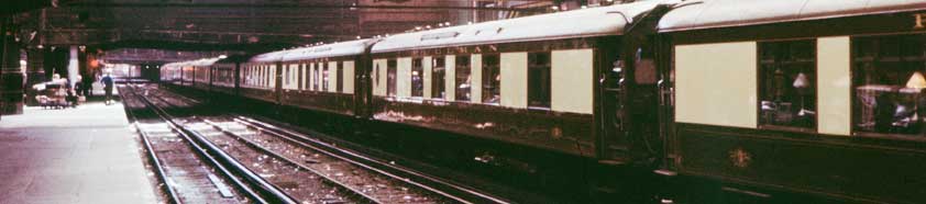
On a bright summer’s day at the railway’s edge, in a quiet field that is now a thronging Gatwick Airport, a raucous two-note horn draws attention to the whine of traction motors that hitherto had gone unnoticed. Clattering over the points, accelerating hard comes a train heading south that is unlike any other. Not green; it’s brown, with a broad cream stripe along its side. Clear to see are its large, rectangular picture windows, with the word PULLMAN written on top of each car side. With the facility that we all have when fascinated for taking in detail, the people can be seen clearly, at each table – for there are tables. All have a white-shaded lamp on them, and what looks like a table cloth, quite unlike any other train. The clattering over the junction goes on for about ten cars or so – counting them is automatic. The last car passes, whining down the rails, and as it diminishes towards Brighton, and the little flashes from the third rail can be seen as it fades into the distance. This wonderful bit of theatre is the Brighton Belle, and the people who saw it in their childhood always added that after that they just had to go on it. Those who did, talk about the uniformed stewards, Pullman service, the big, comfortable chairs, the nonstop hurry of it all. They became supporters.
This is the legacy still in place, 35 years after the train last ran; the Brighton Belle made a much bigger impression than anyone could have imagined. This project is about bringing the train back. This website tells you something about history, the lack of imagination of the 1960s, what the intention restore and run a whole train has meant in real terms, what we’ll get, and what will be done with it. There are three surprising impacts that were unexpected:
Today’s privatised railway did not say no – true, there has been head scratching over how to run an 80 year old train with safety, but as soon as the onerous conditions for this were met, then broad smiles across the board indicated a major welcome, together with understanding over the extended timescale necessary to get things right.
Those who advance a lot of money because they wanted to see such a British Art Deco icon run again have displayed astonishing generosity, and they have made the project possible, sticking with it through ups and downs. The public too have been generous, praising advances and being sympathetic to setbacks.
The promoters, what tough hides they have. It all seemed easy, but it’s not; yet resolve remained solid as a rock. And it still is as the project comes to fruition.